Two weeks ago, Helene came along. You could look from a satellite, how this drama unfolded:

The more the colorings turns to red respectively violet, the faster the wind speeds had been.
Helene reached its peak intensity as a Category 4 storm with maximum sustained winds of 140 mph (225 km/h). It caused extensive damage along Florida’s Big Bend region and other southeastern U.S. states before weakening as it moved inland. The storm produced significant flooding and widespread destruction across multiple states, particularly in the southern Appalachians and coastal areas.
So, here’s the thing with Hurricane Helene – it didn’t behave like a typical hurricane. Normally, these storms are round, with the eye in the center and winds swirling perfectly around it. But as Helene approached Florida, things got a bit strange. The wind pattern started to stretch out, almost as if the storm was getting pulled apart. And that’s not just some random fluke.
One of the big reasons for this is the jet stream. Think of the jet stream like a fast-flowing river of air high up in the atmosphere. When hurricanes run into it, it can mess with their balance, almost like a top being pushed while it’s spinning. The upper part of the storm gets hit by these strong winds and starts to lose its symmetrical shape.
But it wasn’t just the jet stream at play. There was also a frontal system nearby – these are colder air masses, and when they clash with the warm, tropical air of a hurricane, the storm starts to deform. The result? Helene stretched out and looked less organized. This can actually make hurricanes even more unpredictable and dangerous because their impact spreads over a larger area.
And that’s how Helene looked as it swept across the northern parts of the U.S., unleashing torrential downpours with rainfall totals reaching up to 500 liters per square meter in many areas.
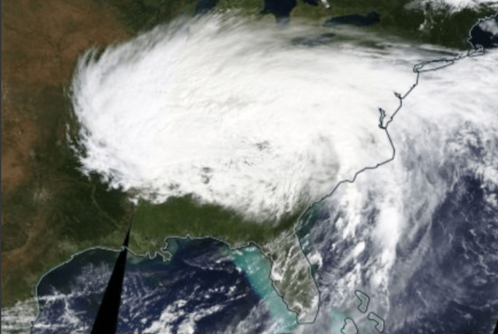
For everyone visible, this thing was huge.
Now two weeks later you can use the same webpage to follow up on another hurricane called Milton: ( https://earth.nullschool.net/#current/wind/isobaric/850hPa/orthographic=-89.01,27.44,2874/loc=-84.515,26.245)
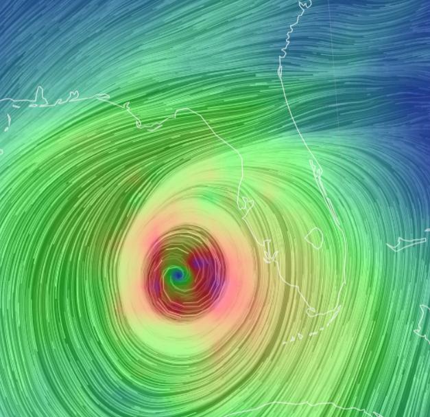
This real-time picture tells quite the story. If you compare how Hurricane Helene looked as it neared landfall—stretched and deformed—Milton looks like the complete opposite. It’s far more symmetrical, with a tightly packed eye wall and clearly defined wind bands spiraling outward. This is a strong indicator that Milton hasn’t yet been disrupted by the usual suspects like land interaction or jet stream interference.
From the look of this image, Milton appears to be even stronger than Helene in terms of wind speed. The wind patterns are denser and more concentrated, especially around the core. That means the hurricane is likely to pack quite a punch as it barrels toward Florida. While Helene’s wind field started to lose its symmetry as it hit the jet stream, Milton hasn’t shown signs of that yet, which means the storm is still very intense.
This tells us that, as climate change continues to warm ocean waters, we will see more storms like Milton—stronger, more organized, and potentially more destructive right until landfall. These types of hurricanes pose an even greater threat because they don’t weaken significantly before hitting populated areas.
So why we let this happen, knowing for a very long time the consequences of our behavior growing like hell through the power of fossil fuels.
The scientific details explaining the increasing likelihood of these extreme weather events, you will find here: https://science.feedback.org/climate-change-impacts-on-the-water-cycle-how-can-it-increase-both-droughts-and-heavy-downpours/
But I think you won’t find the core reason for this path of self-destruction within these brilliant webpages. The core reason from my standpoint is much more simple than the energy imbalance between the earth and sun due to increase in green house gases:
Something deeply is rotten in us, and that has been the case for already a very long time.

In a few hours, the jet stream will give Milton the last push to hit Florida very deeply:
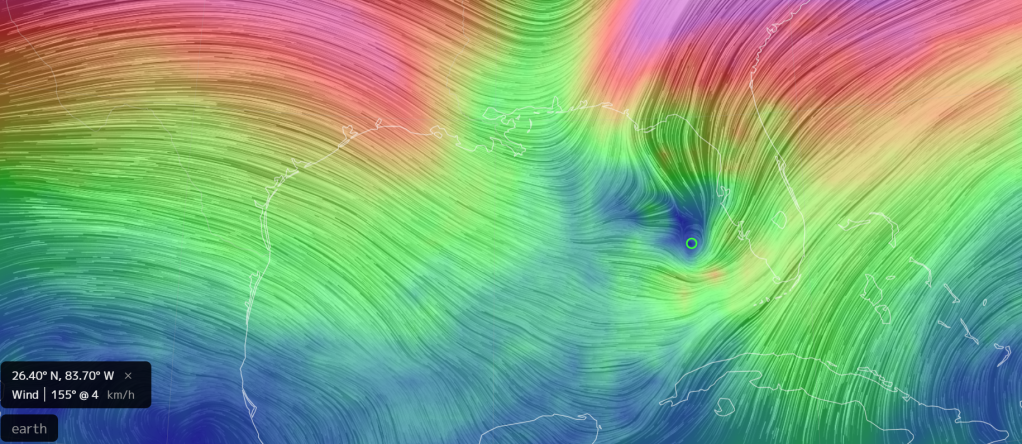
As we look at this image of the jet stream, hovering at 250 hectopascals, it becomes painfully clear what’s about to unfold. Hurricane Milton, with all its fury, is at the mercy of these powerful upper-level winds. The jet stream, acting like an invisible hand, is poised to grab the storm and sweep it across Florida. This means Milton won’t just linger offshore—it’s about to be forced straight through the state, delivering even more destruction than it might have otherwise.
It’s tragic, really. We’re seeing these kinds of interactions—between jet streams and hurricanes—more and more often, driven by a warming atmosphere and shifting weather patterns. This is another reminder of how climate change is making storms not just stronger, but also more unpredictable and widespread in their destruction. As Milton is pushed forward, Florida braces itself for what’s to come: powerful winds, torrential rain, and devastation that will take weeks, if not months, to recover from.
There’s no stopping it now. All we can do is brace ourselves and hope that the damage is less than what these images suggest. But with a storm this powerful, carried by a jet stream this strong, it’s hard to feel optimistic.
